ETV Bharat / science-and-technology

Zooming in through the dark abyss of the cosmos: What’s Chandrayaan’s Google Map in Space?

A lot of excitement filled the air on July 14 as India launched Chandrayaan-3, a mission that captured global attention. It aimed to rectify previous setbacks and inspire the nation, with the countdown to reach the Moon underway. Spearheaded by the Indian Space Research Organization, experts carefully monitored every stage of the journey. But, how exactly does Chandrayaan-3 make its way towards the Moon? Defence and Aerospace analyst Girish Linganna explains…

But the wide universe, perpetually shrouded in impenetrable darkness, is another story altogether! After its successful launch from Sriharikota in Andhra Pradesh, Chandrayaan-3 smoothly exited Earth’s orbit.
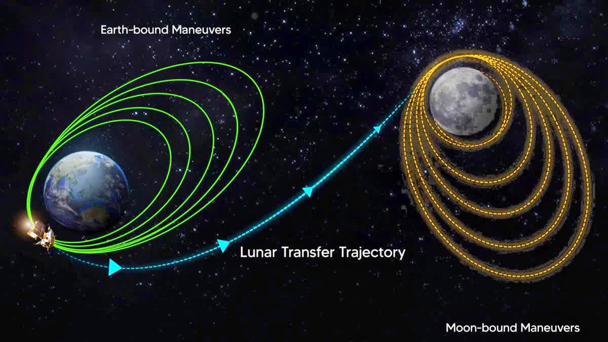
Zooming in through the dark abyss of the cosmos: What’s Chandrayaan’s Google Map in Space? (Source: ISRO)
author img

By

Published : Aug 3, 2023, 6:13 PM IST

Updated : Aug 4, 2023, 11:05 AM IST

New Delhi: “I’m sending you my location on WhatsApp…please come over this evening…,” you tell a friend. “Could I have your Google location please?” asks the delivery boy.

Very familiar statements, aren’t they? Every turn down the narrowest alleyway, every landmark to show us our way in a foreign territory—even how far you’ve travelled on your way…all these seem as easily accessible as never dreamed of before!

Understanding GPS Systems

Global Positioning System (GPS) is a technology that uses a network of satellites in space to help devices on the ground determine their precise location. Devices like smartphones, navigation systems and sports watches receive signals from these satellites and use them to figure out where they are. By measuring how long it takes for the signals to travel from the satellites to the device, GPS can provide accurate information about the device’s location, altitude and speed. This technology is used in many different ways, such as helping people navigate, tracking objects or people—and even for emergency response systems.

Advanced Navigation System

But the wide universe, perpetually shrouded in impenetrable darkness, is another story altogether! After its successful launch from Sriharikota in Andhra Pradesh, Chandrayaan-3 smoothly exited Earth’s orbit. This was a big achievement by itself, but the mission was far from over. How is Chandrayaan-3 threading its way through the wide cosmos without any road signs towards the Moon? And how are our scientists at the Indian Space Research Organisation (ISRO) and other experts worldwide closely tracking its progress path and trajectory through the wide nihility beyond Earth?

Navigation is one of space mission’s most crucial aspects and has two branches—‘position determination’ and ‘attitude determination’. Determining the location of spacecraft according to a fixed coordinate system is called ‘position determination’ and, according to angular coordinates, ‘attitude determination’.

To ensure Chandrayaan-3’s precise navigation in space, ISRO utilized ‘star sensors’ instead of a GPS system. These sensors are helping the spacecraft determine its direction, measure its progress and establish its intended path.

Also read: Next stop: Moon! ISRO cheers as Chandrayaan-3 leaves earth's orbit for moon

A star sensor is one of the precise ‘attitude determination’ sensors. This electro-optical system takes an image from a set of stars, juxtaposes it against the same star pattern from a reference star catalogue, determines the angle of the spacecraft’s deviation and modifies its attitude. Finally, this information is sent to the inertial guidance and control system for attitude correction of the spacecraft. A star sensor comprises a baffle, detector, optical system and an electronic and image-processing system.

The primary function of the star sensors is to quickly and accurately calculate where a spacecraft is pointing in the cosmos, since, for any mission of this kind, it is imperative to know the exact position of the spacecraft. Star sensors are capable of calculating its pointing direction in space by identifying the stars in its field of view (FoV). Since stars are fixed in the cosmos relative to inertial space, they are the best targets for attitude determination. The images obtained from the optical system are compared with a precise star catalogue saved in the spacecraft’s onboard computer.

The star sensors on Chandrayaan-3 are helping the spacecraft find its way in space by using the positions of stars—more precisely, the Meru Nakshatra (Pole Star) and the Sun. The Pole Star, which consistently maintains its position in the north, acts as a reference point to determine other directions. The spacecraft’s star sensors track the Sun in the daytime, and, in the night, negotiate Chandrayaan’3’s passage with the Pole Star to navigate the spacecraft accurately.

As of now, Chandrayaan-3 is located 127,609 kilometres away from Earth and is maintaining its orbit at a distance of 236 kilometres. This important data is collected by the star sensors, providing regular updates on the spacecraft’s movement and progress.

Future Voyage of Chandrayaan-3

According to ISRO, Chandrayaan-3's upcoming mission will unfold in the following manner:

  • On July 25, an important manoeuvre was made to change the spacecraft's orbit, setting the groundwork for the next phase
  • On August 1, the spacecraft’s Vikram lander gradually entered the lunar transfer trajectory or the Moon's gravitational orbit, marking the beginning of its journey towards the Moon
  • By August 5, Chandrayaan-3 successfully attained lunar orbit, signifying its initial approach towards the Moon
  • Following that, on August 6, the spacecraft will enter its second lunar orbit, marking a transition in its orbital path around the Moon
Last Updated : Aug 4, 2023, 11:05 AM IST
ETV Bharat Logo

Copyright © 2025 Ushodaya Enterprises Pvt. Ltd., All Rights Reserved.