ETV Bharat / bharat

China will use Tsangpo river’s steep 2-km-drop to produce power

China’s plan to dam the Tsangpo will produce enormous and very cheap hydropower but will pose a colossal danger to lower riparian regions in Assam, Arunachal Pradesh and Bangladesh, writes senior journalist Sanjib Kr Baruah.

Tsangpo river
Tsangpo river
author img

By

Published : Dec 15, 2020, 5:01 PM IST

New Delhi: China’s supremely ambitious plan to dam the Yarlung Tsangpo-Brahmaputra river in at least two more points in eastern Tibet to generate electricity has no parallel in human history nor in the magnitude of danger it will pose to lower riparian regions in India and Bangladesh.

The plan has at its core an unprecedented and hugely technologically challenging project that includes plunging mind boggling volumes of water down by about 2,000 metres (2 km) through 40-50 km long tunnels, two scientists studying the issue told ETV Bharat.

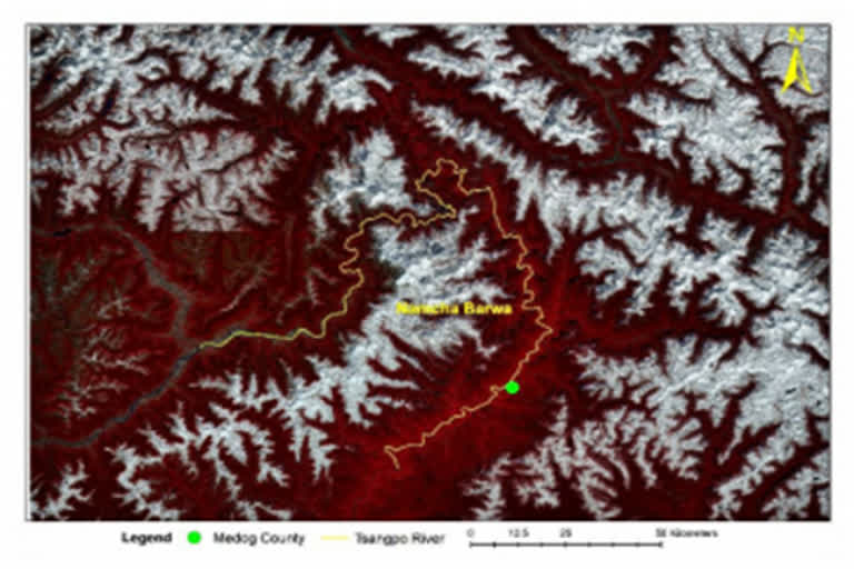
Two of the dam sites have been identified to be in Metok (Medog or Motuo) county and at Daduo (Daduquia) which are located not very far from the Line of Actual Control (LAC) or the defacto border with India.

According to an unpublished article written by the two scientists Dr Nayan Sharma and Dr Dheeraj Kumar: “Both (Motuo and Daduo dams) involve diverting water from the river through a man-made short-cut tunnel that avoids much of the Great Bend, sending huge volumes of water straight across from intercept points where the river is just below 3,000 metres, rushing down to rejoin the river on the far side of the Bend, where it is only at 850 metres (Motuo) or 560 metres (at Daduo).”

The tunnels will be dug underneath mountains that have some of the world’s tallest peaks including the Namcha Barwa (7780 metres) and the Gyala Peri (7293 m) beneath which the frothing Tsangpo takes a 180 degree turn which is called the ‘Great Bend’.

Sharma and Kumar have written in the report: “This (the dams project) makes maximum use of a drop of more than 2 kilometres to drive enormous turbines and produce electricity on a scale that dwarfs even the world’s largest power plant ‘Three Gorges’.”

“Not only have Chinese hydro engineers sketched such plans, they have published proposed routes for the ultra high voltage cables that would then step across the deep gorges of nearby rivers in order to reach the core cities of western China, Chongqing and Chengdu,” the report says.

Recently, Chinese media has also reported that the enormous power generated will also be used to supply electricity to Nepal and China's neighbouring countries.

While the Metok dam is to have a power generating capacity of 38,000 megawatts (MW) power, the Daduquia dam is likely to have a capacity of 43,800 MW. At 18,600 MW production capacity, the world’s biggest ‘Three Gorges dam’, also in China, pales in comparison.

Also read: India is a leading soft power in the world: Minister

A much smaller capacity dam at Zangmo (510 MW) is already operational on the Tsangpo, although at quite a distance west of the ‘Great Bend’.

According to Sharma, the Yarlung Tsangpo waters may hurtle down at an amazing velocity of about 30 metres per second at the dam site which will generate unbelievable power at extremely cheap cost. It means the waters will travel at about 120 km per hour.

Just for perspective, during peak monsoons floods, the mean velocity of the Brahmaputra river flow is between 5-6 metres per second near Guwahati while during the same period, that of the Ganga is at 5 metres per second near Patna.

The two scientists argue that “any reduction of stream flow in the Yarlung Tsangpo, because of climate change or artificial flow diversion in coming years, will have very serious impact on the quantum of water resources in downstream areas of the Brahmaputra in India and Bangladesh, besides greatly depleting the non-monsoon dry weather flows.”

“In the event of likely major earthquake, any possible failure of the above series of big dams on the Yarlung Tsangpo at an altitude of over 3 km above Assam plains in eastern Tibet may pose very serious hazard for the Indian plains in Arunachal Pradesh and Assam state.”

“Furthermore, due to any river diversion of the Yarlung Tsangpo, other important water uses namely – ecology, inland navigation and drinking water will be very severely hit especially in the non-monsoon low flow period,” the report adds.

Sharma has worked for 45 years on river engineering projects across the world including decades as part of the faculty in IIT Roorkee. Having completed more than 50 consultancy projects, Kumar has written more than 20 research papers and articles in national and international journals on water resources engineering.

ETV Bharat Logo

Copyright © 2025 Ushodaya Enterprises Pvt. Ltd., All Rights Reserved.