 D S Hooda")

New Delhi: The tragic death of 20 soldiers, including a commanding officer, has brought home the gravity of the situation along the Line of Actual Control (LAC) in Ladakh. This is perhaps the biggest crisis between India and China since 1962 and would have a long-term impact on the relations between the two countries. Often, for the general public, there is a desire to understand the basis of the problem, the geography of the area, and how the current standoff between the two armies could play out. I will attempt to put these issues into perspective.
The LAC
During the 1962 war, the Chinese Army captured about 38,000 square kilometers of area in Western Ladakh. The de facto border that was created due to the Chinese occupation of Indian territory came to be called the LAC. Since this LAC was neither delineated on maps nor demarcated on the ground, both sides have a differing perception of the LAC in certain areas.
Both Indian and Chinese armies patrol up to their perception of the LAC, and in areas where there are differences, patrols of the two sides often come face to face with each other. To ensure that these faceoffs are peacefully concluded, there are numerous agreements and protocols to guide the conduct of soldiers on both sides. As an example, Article VIII of the 2013 'Border Defence Cooperation Agreement' states:
"The two sides agree that if the border defence forces of the two sides come to a face-to-face situation in areas where there is no common understanding of the line of actual control, both sides shall exercise maximum self-restraint, refrain from any provocative actions, not use force or threaten to use force against the other side, treat each other with courtesy and prevent exchange of fire or armed conflict."
The strict observance of protocols on both sides had ensured that the LAC remained peaceful since 1975 when four Indian soldiers were killed in a border incident. This has now suddenly changed with the Chinese incursions that occurred in the first week of May.
Eastern Ladakh Geography
Ladakh is called a high-altitude desert and areas of Eastern Ladakh lie adjacent to the Tibetan Plateau. The Pangong Tso lake and the Galwan River Valley lie at the height of 14,000 feet, and the area of Hot Spring is at 15,500 feet. These are the three areas where the standoff with the Chinese is currently taking place.
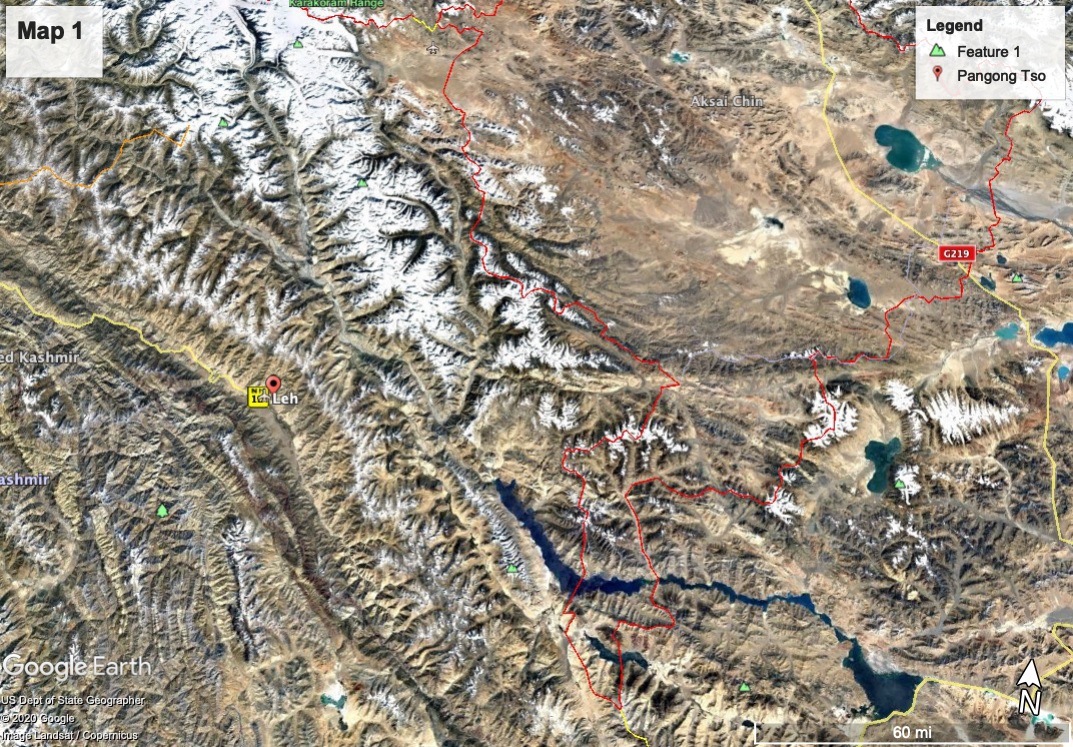
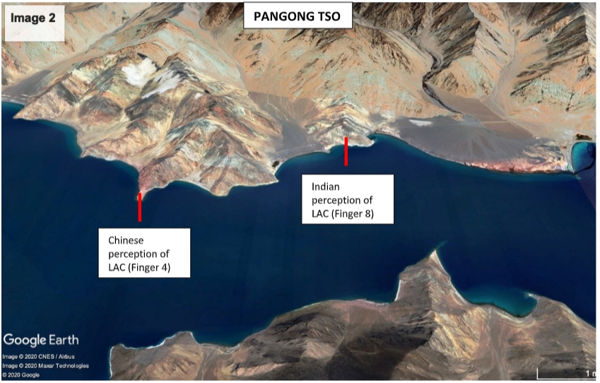
Major tension has erupted in the Pangong Tso and Galwan areas. At the North bank of the Pangong Tso, both India and China have a different perception of the LAC, and in the past, both sides were patrolling up to their respective claimed areas. China claims that the LAC lies at Finger 4, while India’s perception is further east at Finger 8. Currently, the Chinese have physically occupied areas that were claimed by them, effectively denying access to India troops from patrolling up to our perception of the LAC.
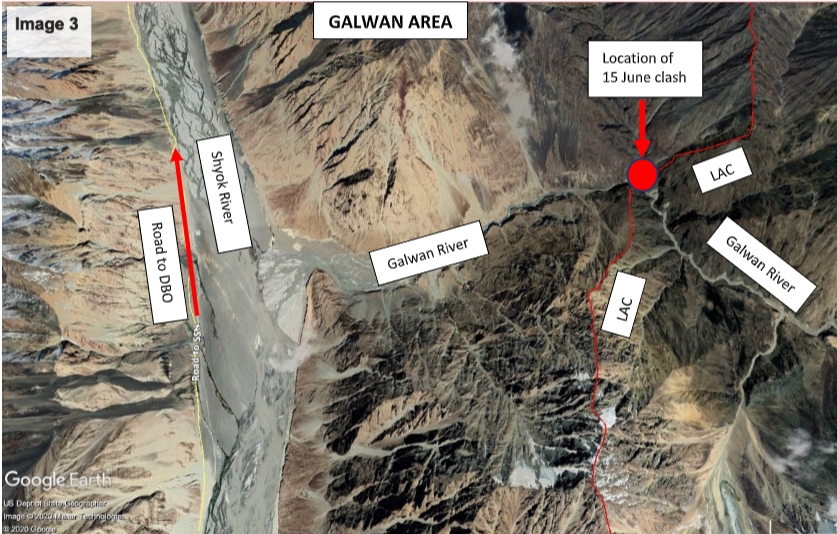
The LAC at the Galwan Valley is approximately six kilometers from an important Indian road that goes up to Daulat Beg Oldi (DBO), the highest airstrip in the world. This is the only all-weather road that resupplies our soldiers that are deployed in and around DBO. The road starts from Darbuk and travels 255 kilometers to DBO. The construction of the road started in 2000 but its use for the army was hampered because there was no bridge over the Shyok River. A permanent bridge was completed in 2019 and inaugurated by the Raksha Mantri. The road has acquired a very strategic character as soldiers and military equipment can now be speedily inducted into the northern areas of Ladakh.
If the Chinese enter the LAC through the Galwan Valley, they could threaten to cut off this critical road. The Indian soldiers have strongly resisted Chinese attempts to intrude into our area, and it was one such clash on 15 June that led to the martyrdom of 20 soldiers.
How serious is the situation?
There have been several intrusions in the past, some of which have led to extended standoffs like Depsang in 2013, Chumar in 2014, and Dokalam in 2017. However, these were localized incidents that were resolved peacefully without any violence on both sides. The current Chinese actions are entirely different. The Chinese build-up across different sectors of the LAC is in large numbers and has obviously been approved at the highest level in the Chinese government. The violence that accompanied the Chinese military moves is unprecedented, and all the protocols that guided the conduct of the two armies appear to have completely broken down.
The Chinese actions have forced a reassessment of the rules of engagement that guide Indian soldiers' conduct on the LAC, and we are bound to see more aggressive behaviour. This has long-term implications for border management, and we could see a hotter LAC, at least in the near future.
The nature and quality of India-China relations are also bound to suffer, and signs of this are already visible. There is an anti-Chinese sentiment that is sweeping through the country, and irrespective of how the situation is resolved, citizens of this country will not forget this Chinese attempt to intimidate India through a show of military power.
Courtesy: Lt Gen D S Hooda, Former Chief of Indian Army's Northern Command