ETV Bharat / bharat

China dam-inventory map includes sites in Arunachal

A decade-old map purportedly drawn by Hydrochina Corporation, China’s biggest state-owned company that plans and executes the entire range of technical services in hydropower and water resources development, shows dam sites in areas that come under Arunachal Pradesh. Marked as a project inventory map belonging to Hydrochina, the image, with Arunachal sites marked in Mandarin, also include sites in Taiwan. Both these areas are not under Chinese control, reports senior journalist Sanjib Kr Baruah.

Representative Image
author img

By

Published : Oct 6, 2020, 4:42 PM IST

New Delhi: Underlining its relentless and unceasing territorial claim on Arunachal Pradesh, there are grand Chinese designs on harnessing the rich water resources of Northeast India’s biggest state.

A decade-old map purportedly drawn by Hydrochina Corporation, China’s biggest state-owned company that plans and executes the entire range of technical services in hydropower and water resources development, shows dam sites in areas that come under Arunachal Pradesh.
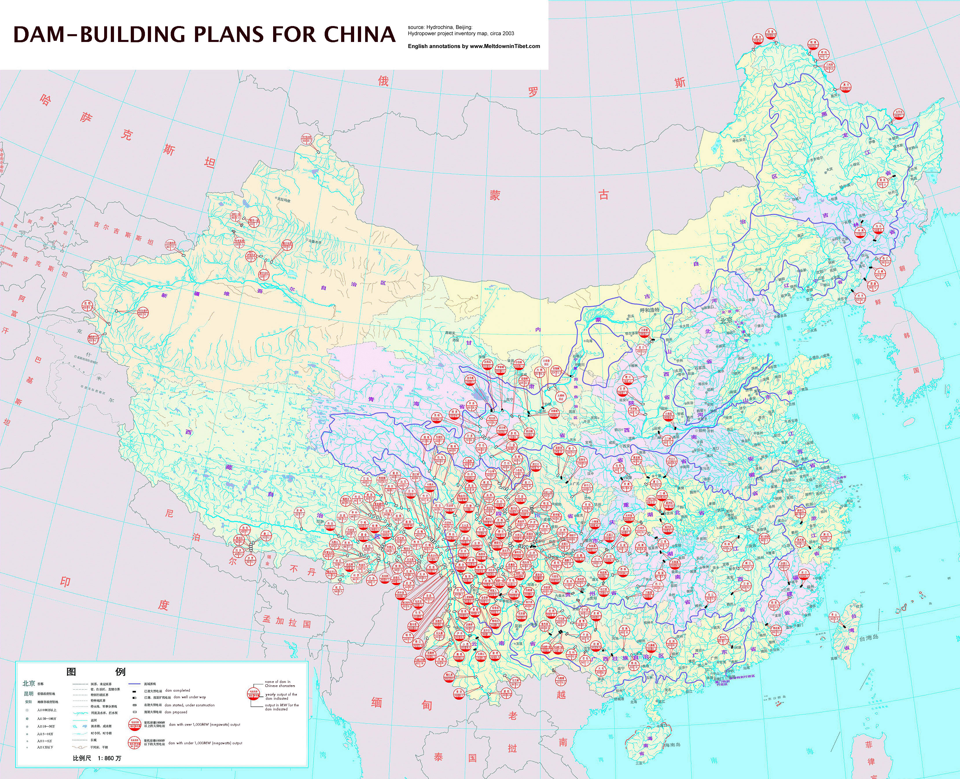
Dam-building plans for China

Marked as a project inventory map belonging to Hydrochina, the image, with Arunachal sites marked in Mandarin, also include sites in Taiwan. Both these areas are not under Chinese control.

The latest internet search shows that the company’s official website has taken out the map in question as the link leads to an ‘error’ page.

India and China are engaged in an escalating military face-off across eastern Ladakh and other border areas since April-end.

It has resulted in an unprecedented mobilization of troops and war equipment that shows no signs of easing amid the failure of most consultation mechanisms even as the two armies are preparing to dig in for the brutal winter that is just setting in.

Also Read: NE insurgents up ante as India, Myanmar talk to clean 'Wild East'

With water rights expected to be one of the biggest triggers for future wars, it is no wonder that China covets Arunachal Pradesh—one of the world’s most hydro-water-resource-rich regions.

While the McMahon Line (ML) demarcates Indian and Tibetan territory, China has refused to acknowledge the ML and instead has been referring to Arunachal Pradesh since 2006 as ‘southern Tibet’ based on historical ties of the NE state to Tibet.

Saying all Chinese maps include Arunachal Pradesh, Claude Arpi, leading Tibetologist and keen China watcher, told ETV Bharat: "They can’t plan dams for Arunachal, they are not in possession. It is just a claim to bargain for Aksai Chin in the west."

While north China is water-parched, the south is rich in water resources holding up to 80 per cent of the country’s water resources.

Ensuring control, conserving and efficiently utilizing its water resources has been an abiding challenge for China, the requirement of which is growing by the day along with rapid economic growth.

Also Read: For China, Ladakh may be ruse, Arunachal the real muse

One of China's biggest names as far as hydro-water planning goes is former water resources minister Wang Shucheng, who once famously said: “To fight for every drop of water or die that is the challenge facing China.”

Not without reason is China the world’s biggest builder of dams. China has about 80,000 dams of which more than one-fourth are mega-dams.

Part of an ongoing ambitious plan is to divert waters from the southern rivers in the Tibetan plateau, including the Yarlung Tsangpo (which becomes the Brahmaputra in Assam) to the dry and arid northern region, for which many dam projects are already in place.

Arpi says: “A mega-dam on the Yarlung Tsangpo is very tricky technologically and risky due to the seismicity of the area. It will hopefully not happen.”

Also Read: War clouds gather as Pak opens India gambit with November GB move

ETV Bharat Logo

Copyright © 2025 Ushodaya Enterprises Pvt. Ltd., All Rights Reserved.