ETV Bharat / state

Joshimath sinking due to moraine debris left by glacier, suspect environmentalists

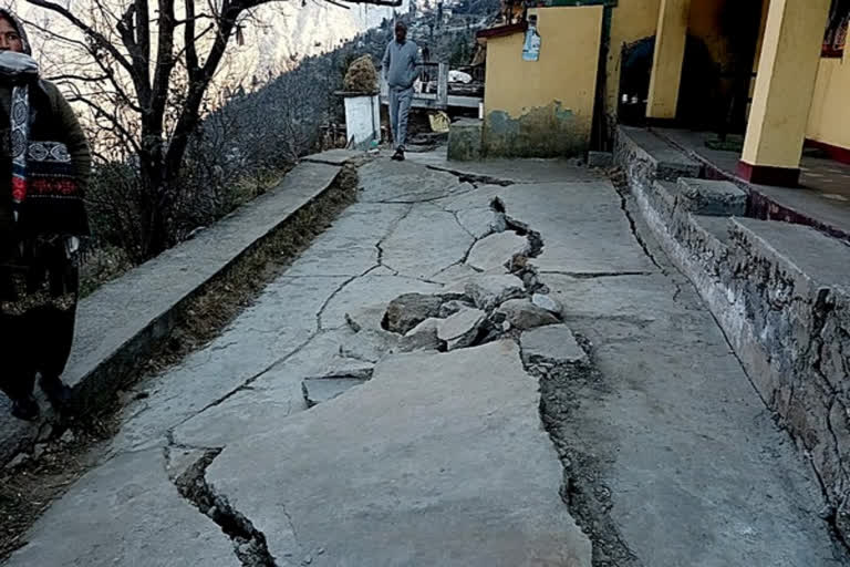
The Joshimath town in Uttarakhand is sinking now because it might have settled on 'moraine' landforms of debris, soil, and rocks left by a moving glacier, say environmentalists. The present problem is also man-made as heavy construction work has caused a huge burden on mountain regions.

Environmentalists believe the cause for land subsidence here is based on the moraine theory.
Cracks developed in a house in Joshimath
author img

By

Published : Jan 13, 2023, 1:01 PM IST

Updated : Jan 13, 2023, 4:22 PM IST

Environmentalist JP Maithani interacts with media

Dehradun: With ISRO satellite image showing that Joshimath sank 5.4 cm in just 12 days causing grave concern not only to the state government and the 17000-odd people living in the Himalayan town. Though many blame the Tapovan Vishnugad hydroelectric project to be the main reason behind the subsidence environmentalists are of opinion that 'moraines' of debris, soil, and rock are the main reasons behind landslides in this holy city of Uttarakhand.

According to environmentalists, moraines are landforms composed of glacial till deposited primarily by glacial ice. Moraines may be found on the glacier's surface or deposited as piles or sheets of debris where the glacier has melted. Interestingly enough the environmentalists here have drawn parallels between Uttarakhand's 'sinking town' and the devastating Kedarnath floods.

Expressing concerns over the protracted problem of land sinking in Joshimath, environmentalist JP Maithani of Uttarakhand said, “Both incidents are not mutually exclusive. The Kedarnath flash floods were a wake-up call but we neglected it. The Joshimath issue is a result of burdening mountainous regions with heavy construction work”.

Experts are of opinion that Joshimath is settled on the debris of old landslides and that is the main reason behind the subsidence in the Himalayan town. Apart from Joshimath reports of subsidence are coming from several places in Uttarakhand including Uttarkashi, Tehri, Pauri, and Karanprayag and this itself substantiates the claims made by the environmentalist.

Referring to the Mishra Committee report on the continuous shifting of land in Joshimath, environmentalists have expressed concerns over the reconstruction of Kedarnath after the 2013 flash floods. The committee report took into consideration all the documents and talks about the sinking town of Joshimath. The report further substantiates the moraine theory behind the present-day land subsidence issue.

Also read: ISRO's satellite images shows Joshimath sank 5.4 cm in just 12 days

Interestingly enough a report from National Thermal Power Corporation Limited (NTPC) also supports the view. The report submitted by the NTPC to the power ministry said that a 12-kilometer long tunnel connected to the Tapovan Vishnugad hydroelectric project is 1 kilometer away from Joshimath town and more than a kilometer below the ground and has no role in the subsidence of the region.

The Thermal Corporation citing a state government-appointed M C Mishra Committee said that Joshimath is a very old issue with first observance dating back to 1976 and it blamed the "hill wash, natural angle of repose, cultivation area because of seepage and soil erosion" for the subsidence and cracks.

According to the report, the construction work of the 4x130 MW Tapovan Vishnugad project started in November 2006. The project includes the construction of a concrete barrage at Tapovan (15 km upstream of Joshimath town). The company said during the construction of the tunnel, locals had raised concerns about the drying of the water table in the future in the Selong area, which is about 6 km away from Joshimath Town. An expert committee was constituted by DM Chamoli which in August 2010 concluded that "there is no ground evidence of any instability induced by HRT excavation using TBM."

Last Updated : Jan 13, 2023, 4:22 PM IST
ETV Bharat Logo

Copyright © 2025 Ushodaya Enterprises Pvt. Ltd., All Rights Reserved.