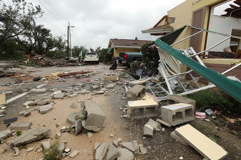
New Orleans: Rain pounded the US Gulf Coast on Sunday ahead of the arrival of Tropical Storm Cristobal, which has already spawned a tornado in Florida and threatened more twisters along with high winds and storm surge.
Roads flooded in coastal Louisiana and Mississippi, and thousands were without power even before the storm made landfall. It was expected to arrive on US soil late Sunday, though it was not expected to grow into a hurricane.
Read also: Australia prepares for 'once-in-a-decade' storm
Forecasters warned the storm would affect a wide area stretching roughly 180 miles (290 kilometers) east into Florida. But they forecast the worst impacts in southeast Louisiana and southern Mississippi, where some spots could get up to 12 inches of rain and storm surges of several feet. Tornadoes were also a danger.
"It's very efficient, very tropical rainfall," National Hurricane Center Director Ken Graham said in a Facebook video. "It rains a whole bunch real quick."
On evacuated Grand Isle in Louisiana, a highway was underwater and much of the island wasn't passable, Jefferson Parish Councilman Ricky Templet told The Times-Picayune/New Orleans Advocate.
Read also: Cyclone Nisarga LIVE Updates: 3 killed as cyclonic storm reaches Pune
Templet plans to stay on the island during the storm and said he hasn't seen water levels this high since a 2012 hurricane.
The Sewerage & Water Board of New Orleans said the city's drainage system had limits and was old, so residents should avoid underpasses and low-lying areas where water can pool during inevitable street flooding.
In Biloxi, Mississippi, a pier was almost submerged by Sunday morning. Squalls with tropical-force winds had reached the mouth of the Mississippi River and conditions were expected to deteriorate, the National Hurricane Center in Miami said. Cristobal's maximum sustained winds remained at 50 mph (85 kph), and it was moving north at 12 mph (19 kph).
But the storm already made its presence felt Saturday evening with a tornado that touched down near downtown Orlando, the National Weather Service said. The twister just missed a group of protesters at Lake Eola at around 7:30 p.m. There appeared to be no injuries, but tree limbs were knocked down, and there were reports of power outages.
"Yes, it is related to the tropical storm that is well to our west," said Scott Kelly, a meteorologist with the National Weather Service in Melbourne, Florida. "But the tropical storm provided a lot of low level shear and that has allowed for some tornadoes to form over Central Florida."
A tropical storm warning was posted for the northern Gulf of Mexico coast from Intracoastal City, Louisiana, to the Alabama-Florida border. Storm surge warnings and watches were in effect in Louisiana and Mississippi, with flooding up to 5 feet (1.5 meters) expected in some places.
Forecasters said the storm's center will move inland across Louisiana late Sunday through early Monday and then head north across Arkansas and Missouri on Monday afternoon and into Tuesday.
In Louisiana, Gov. John Bel Edwards has declared a state of emergency to prepare for the storm's possible arrival.
"Now is the time to make your plans, which should include the traditional emergency items along with masks and hand sanitizer as we continue to battle the coronavirus pandemic," Edwards said in a statement released Thursday.
On Friday, he asked President Donald Trump to declare a pre-landfall emergency for the state due to the storm's threat.
"We are confident that there will be widespread, heavy rainfall and coastal flooding," Edwards said in a letter to the White House. "I anticipate the need for emergency protective measures, evacuations, and sheltering for the high-risk areas. The length of possible inundation is unknown and will likely require post-flood activities."
Jefferson Parish, a suburb of New Orleans, called for voluntary evacuations Saturday of Jean Lafitte, Lower Lafitte, Crown Point and Barataria because of the threat of storm surge, high tides and heavy rain. Residents were urged to move vehicles, boats and campers to higher ground.
"We want to make sure residents are safe as this storm approaches so we are taking all the necessary precautions to be fully prepared," Jean Lafitte Mayor Tim Kerner Jr. told The Times-Picayune/The New Orleans Advocate.
A similar order was issued Saturday for several Plaquemines Parish communities, including Happy Jack, Grand Bayou, Myrtle Grove, Lake Hertiage, Harlem and Monsecour. The parish's president, Kirk Lepine, said the order was issued as a precaution.
"We need to ensure residents are protected as this storm draws near, so we are taking all the necessary precautions to be completely prepared," he said.
AP


