ETV Bharat / international

California wildfire advances as heat wave blankets US West

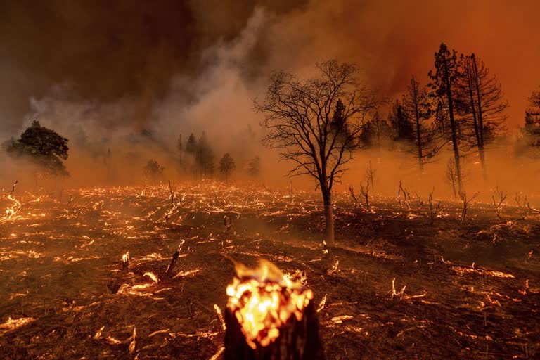
Firefighters struggled to contain an exploding Northern California wildfire under blazing temperatures as another heatwave hits the US West this weekend, prompting an excessive heat warning for inland and desert areas.

California wildfire advances as heat wave blankets US West
author img

By

Published : Jul 11, 2021, 7:29 AM IST

Beckwourth: Firefighters struggled to contain an exploding Northern California wildfire under blazing temperatures as another heatwave hits the US West this weekend, prompting an excessive heat warning for inland and desert areas. On Friday, Death Valley National Park in California recorded a staggering high of 130 degrees Fahrenheit (54 Celsius) and could reach the same high on Saturday. If verified, the 130-degree reading would be the hottest high recorded there since July 1913, when the same Furnace Creek desert area hit 134 F (57 C), considered the highest reliably measured temperature on Earth.

The Beckwourth Complex a merging of two lightning-caused fires headed into Saturday showing no sign of slowing its rush northeast from the Sierra Nevada forest region after doubling in size only a few days earlier. California's northern mountain areas already have seen several large fires that have destroyed more than a dozen homes. Although there are no confirmed reports of building damage, the fire prompted evacuation orders or warnings for roughly 2,800 people in California along with the closure of nearly 200 square miles (518 square kilometres) of Plumas National Forest.

Read: Black box from crashed Philippine military plane retrieved

On Friday, ridgetop winds up to 20 mph (32 kph) combined with ferocious heat as the fire raged through dry pine, fir and chaparral. As the fire's northeastern flank raged near the California-Nevada state line, the Washoe County Sheriff's Office asked people to evacuate some areas in the rural communities of Ranch Haven and Flanagan Flats, north of Reno. Evacuate now, a sheriff's office tweet said. Hot rising air formed a gigantic, smoky pyrocumulus cloud that reached thousands of feet high and created its own lightning, fire information officer Lisa Cox said.

Spot fires caused by embers leapt up to a mile (1.6 kilometres) ahead of the northeastern flank too far for firefighters to safely battle, and winds funnelled the fire up draws and canyons full of dry fuel, where it can actually pick up speed, Cox said. Firefighters usually take advantage of cooler, more humid nights to advance on a fire, Cox said, but the daytime conditions persisted. More than 1,200 firefighters were aided by aircraft but the blaze was expected to continue forging ahead because of the heat and low humidity that dried out vegetation.

The air was so dry that some of the water dropped by aircraft evaporated before reaching the ground, she added. We're expecting more of the same the day after and the day after and the day after, Cox said. The blaze, which was only 9 per cent contained, increased dramatically to 86 square miles (223 square kilometres) after fire officials made better observations. It was one of several threatening homes across Western states that are expected to see triple-digit heat through the weekend as a high-pressure zone blankets the region.

The National Weather Service warned the dangerous conditions could cause heat-related illnesses, while California's power grid operator issued a statewide Flex Alert from 4 p.m. to 9 p.m. Saturday to avoid disruptions and rolling blackouts. Flex Alerts call for consumers to voluntarily conserve electricity by reducing the use of appliances and keeping the thermostat higher during evening hours when solar energy is diminished or no longer available. Meanwhile, other fires were burning in Oregon, Arizona and Idaho.

Read: 52 dead, 50 injured due to factory fire in central Bangladesh

In Oregon, pushed by strong winds, a wildfire in Klamath County grew from nearly 26 square miles (67 square kilometres) Thursday to nearly 61 square miles (158 square kilometres) on Friday in the Fremont-Winema National Forest and on private land. An evacuation order was issued for people in certain areas north of Beatty and near Sprague River. That fire was threatening transmission lines that send electricity to California, which along with expected heat-related demand prompted California Gov. Gavin Newsom on Friday to issue an emergency proclamation suspending some rules to allow for more power capacity.

In north-central Arizona, increased humidity slowed a big wildfire that posed a threat to the rural community of Crown King. The 25-square-mile (64-square-kilometre) lightning-caused fire in Yavapai County was 29 per cent contained as of Friday. Recent rains allowed five national forests and state land managers to lift public-access closures. In Idaho, Gov. Brad Little declared a wildfire emergency Friday and mobilised the state's National Guard to help fight fires sparked after lightning storms swept across the drought-stricken region.

Fire crews in north-central Idaho were facing extreme conditions and gusts as they fought two wildfires covering a combined 19.5 square miles (50.5 square kilometres). The blazes threatened homes and forced evacuations in the tiny, remote community of Dixie about 40 miles (64 kilometres) southeast of Grangeville.

(AP)

ETV Bharat Logo

Copyright © 2024 Ushodaya Enterprises Pvt. Ltd., All Rights Reserved.