ETV Bharat / briefs

Cyclone alert: Depression over Indian Ocean intensifies

The depression over the Indian Ocean and southeast Bay of Bengal has intensified. It is very likely to intensify into a cyclonic storm during next 12 hours. Fishermen are warned against venturing into the sea.

Cyclone alert: Depression over Indian Ocean intensifies
author img

By

Published : Apr 27, 2019, 2:20 PM IST

Updated : Apr 27, 2019, 5:36 PM IST

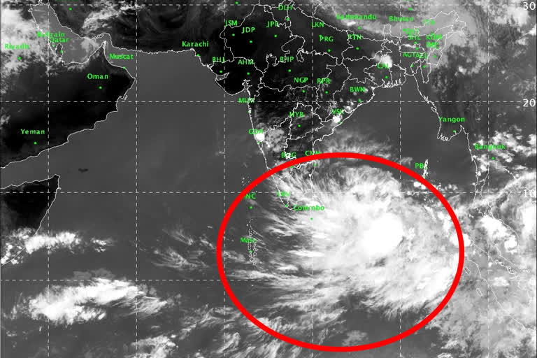
Chennai: Warning fishermen against venturing into the sea, the India Meteorological Department (IMD) on Saturday has said that the depression over the Indian Ocean and southeast Bay of Bengal has intensified and moved further northwestwards. It is very likely to intensify into a cyclonic storm during next 12 hours and further into a severe cyclonic storm during subsequent 24 hours.

"The depression over east Equatorial Indian Ocean and adjoining southeast Bay of Bengal moved further northwestwards, intensified into a deep depression and lay centered about 870 km east-southeast of Trincomalee (Sri Lanka), 1210 km southeast of Chennai and 1500 km south-southeast of Machilipatnam in Andhra Pradesh," IMD informed. Further, the system is very likely to move northwestwards off Sri Lanka coast during the next 72 hours and reach near north Tamil Nadu and south Andhra Pradesh coasts on April 30.

"On Sunday, gale wind speed reaching 80-90 kmph gusting to 100 kmph and very rough to high seas are very likely over southwest Bay of Bengal adjoining east Equatorial Indian Ocean along and off Sri Lanka coast," the weather office said.

There would be strong wind speed reaching 30-40 kmph gusting to 50 kmph along and off Tamil Nadu and Puducherry coasts, Comorin area, Gulf of Mannar and over Kerala.

Also read: RBI to issue new Rs 20 denomination banknotes

ZCZC
PRI GEN NAT
.CHENNAI MDS1
TN-DEPRESSION
Depression over Indian Ocean intensifies, likely to become cyclone
         Chennai, Apr 27 (PTI) A depression over the Indian Ocean and southeast Bay of Bengal has intensified and moved further northwestwards, the India Meteorological Department (IMD) said Saturday.
         It is very likely to intensify into a cyclonic storm during next 12 hours and further into a severe cyclonic storm, the IMD said and warned fishermen against venturing into the sea on Sunday.
"The depression over east Equatorial Indian Ocean and adjoining southeast Bay of Bengal moved further northwestwards, intensified into a deep depression and lay centered about 870 km east-southeast of Trincomalee (Sri Lanka), 1210 km southeast of Chennai and 1500 km south-southeast of Machilipatnam in Andhra Pradesh," it said.
"It is very likely to intensify into a cyclonic storm during next 12 hours and further into a severe cyclonic storm during subsequent 24 hours," the IMD said.
         Further, the system is very likely to move northwestwards off Sri Lanka coast during the next 72 hours and reach near north Tamil Nadu and south Andhra Pradesh coasts on April 30.
         On Sunday, gale wind speed reaching 80-90 kmph gusting
to 100 kmph and very rough to high seas are very likely over
southwest Bay of Bengal adjoining east Equatorial Indian Ocean
along and off Sri Lanka coast, the weather office said.
         There would be strong wind speed reaching 30-40 kmph
gusting to 50 kmph along and off Tamil Nadu and Puducherry
coasts, Comorin area, Gulf of Mannar and over Kerala, it said.
         "Fishermen are advised not to venture into these areas," it said in its "Weather Warning". PTI SA ROH
DPB
04271303
NNNN
Last Updated : Apr 27, 2019, 5:36 PM IST
ETV Bharat Logo

Copyright © 2025 Ushodaya Enterprises Pvt. Ltd., All Rights Reserved.