ETV Bharat / bharat

Yaas completes landfall, heavy rain to continue: DG IMD

As the 'very severe cyclonic storm' Yaas has completed its landfall process in coastal areas of Odisha and West Bengal, Director General of India Meteorological Department (IMD) Mrutyunjay Mohapatra, in an exclusive conversation with ETV Bharat correspondent Niyamika Singh, speaks about the movement, intensity and impact of the impending storm.

Yaas completes landfall, heavy rain to continue: DG IMD
author img

By

Published : May 26, 2021, 9:35 PM IST

Updated : May 26, 2021, 10:26 PM IST

Question: What is the current status of cyclone Yaas? What will be its further movement?

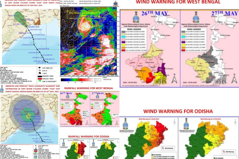
DG: Cyclone Yaas crossed Odisha coast at about 20 km south of Balasore between 10:30 and 11:30 hours IST, today. After landfall, it moved northwestwards and weakened into a severe cyclone around 12:30 hours IST. It will continue to move northwestwards and weakening gradually. It will weaken into a cyclonic storm during the next 3-4 hours.

Thereafter, towards midnight or early hours, it may weaken into a deep depression and tomorrow morning, it will be depression over Jharkhand.

Yaas completes landfall, heavy rain to continue: DG IMD

Read:| Cyclone Yaas Live: IMD suggests fishermen to not venture in sea

Question: What was the intensity of cyclone Yaas during its landfall?

DG: The wind speed was about 130-140 kmph gusting to 150 kmph during the time of landfall. This type of wind prevailed, starting from Bhadrak to the Balasore district, as it approached the early morning hours on Wednesday till noon.

Question: What was the estimated impact of cyclone Yaas in the affected areas?

DG: While moving, it will have some partial damaging impact because of its wind speed over the interior districts of Odisha. The coastal districts of Balasore and Bhadrak will have an impact for the next 3-4 hours, in terms of strong winds and also storm surge in low lying areas.

The heavy rainfall has reduced over the coastal areas. However, in the next 6 hours, you can expect heavy rainfall for the coastal districts of Odisha and interior districts of North Odisha will have heavy to very heavy rainfall during the next 12 hours. Similarly, the adjoining districts of West Bengal and Bihar also will get heavy to very heavy rainfall. Jharkhand can get heavy to extremely heavy rainfall on Wednesday and Thursday.

Question: How severe was cyclone Yaas if we compare it with the previous cyclones which formed in the Bay of Bengal?

DG: It was a very severe cyclone but if you compare it with last year's cyclone Amphan, it had got wind speed of 185 kmph. Whereas cyclone Yaas had a wind speed of 155 kmph. So, in comparison with Amphan, it was more severe with a wind speed of 30 kmph more than that of cyclone Yaas.

Read:| Authorities brace for Cyclone Yaas amid evacuations

Question: Would cyclone Yaas make any impact on this year's Southwest Monsoon?

DG: Cyclone is a temporary phenomenon. On Thursday it will dissipate. Thereafter, the environment will return to its initial condition. Therefore, I do not feel that it will have any long term impact on Monsoon.

Question: Any suggestions or warnings for the people living in the coastal areas which have got hit by the Cyclone?

DG: The sea condition is improving but still it will remain disturbed till May 27. Therefore, our fishermen warning stands. Fishermen should not enter into sea till Thursday morning. Similarly, our naval operations need to be regulated till 27 May morning.

Question: How IMD tracked cyclone Yaas and how its predictions helped in reducing the destruction in affected regions?

DG: IMD has a full-fledged Cyclone Warning System. It is recognised to provide cyclonic services not only in India but also in other countries nearby the Bay of Bengal and the Arabian Sea. Over the years, it has grown with Science and Technology, in collaboration with all the Ministry of Earth Sciences organisations. All of us work together and IMD is the nodal agency to provide the cyclonic services.

We have also gone for improving our observational systems, communication systems, modelling system to improve our early warning system.
Read:| Cyclone Yaas rips through southern West Bengal

Question: What is the current status of cyclone Yaas? What will be its further movement?

DG: Cyclone Yaas crossed Odisha coast at about 20 km south of Balasore between 10:30 and 11:30 hours IST, today. After landfall, it moved northwestwards and weakened into a severe cyclone around 12:30 hours IST. It will continue to move northwestwards and weakening gradually. It will weaken into a cyclonic storm during the next 3-4 hours.

Thereafter, towards midnight or early hours, it may weaken into a deep depression and tomorrow morning, it will be depression over Jharkhand.

Yaas completes landfall, heavy rain to continue: DG IMD

Read:| Cyclone Yaas Live: IMD suggests fishermen to not venture in sea

Question: What was the intensity of cyclone Yaas during its landfall?

DG: The wind speed was about 130-140 kmph gusting to 150 kmph during the time of landfall. This type of wind prevailed, starting from Bhadrak to the Balasore district, as it approached the early morning hours on Wednesday till noon.

Question: What was the estimated impact of cyclone Yaas in the affected areas?

DG: While moving, it will have some partial damaging impact because of its wind speed over the interior districts of Odisha. The coastal districts of Balasore and Bhadrak will have an impact for the next 3-4 hours, in terms of strong winds and also storm surge in low lying areas.

The heavy rainfall has reduced over the coastal areas. However, in the next 6 hours, you can expect heavy rainfall for the coastal districts of Odisha and interior districts of North Odisha will have heavy to very heavy rainfall during the next 12 hours. Similarly, the adjoining districts of West Bengal and Bihar also will get heavy to very heavy rainfall. Jharkhand can get heavy to extremely heavy rainfall on Wednesday and Thursday.

Question: How severe was cyclone Yaas if we compare it with the previous cyclones which formed in the Bay of Bengal?

DG: It was a very severe cyclone but if you compare it with last year's cyclone Amphan, it had got wind speed of 185 kmph. Whereas cyclone Yaas had a wind speed of 155 kmph. So, in comparison with Amphan, it was more severe with a wind speed of 30 kmph more than that of cyclone Yaas.

Read:| Authorities brace for Cyclone Yaas amid evacuations

Question: Would cyclone Yaas make any impact on this year's Southwest Monsoon?

DG: Cyclone is a temporary phenomenon. On Thursday it will dissipate. Thereafter, the environment will return to its initial condition. Therefore, I do not feel that it will have any long term impact on Monsoon.

Question: Any suggestions or warnings for the people living in the coastal areas which have got hit by the Cyclone?

DG: The sea condition is improving but still it will remain disturbed till May 27. Therefore, our fishermen warning stands. Fishermen should not enter into sea till Thursday morning. Similarly, our naval operations need to be regulated till 27 May morning.

Question: How IMD tracked cyclone Yaas and how its predictions helped in reducing the destruction in affected regions?

DG: IMD has a full-fledged Cyclone Warning System. It is recognised to provide cyclonic services not only in India but also in other countries nearby the Bay of Bengal and the Arabian Sea. Over the years, it has grown with Science and Technology, in collaboration with all the Ministry of Earth Sciences organisations. All of us work together and IMD is the nodal agency to provide the cyclonic services.

We have also gone for improving our observational systems, communication systems, modelling system to improve our early warning system.

Read:| Cyclone Yaas rips through southern West Bengal

Last Updated : May 26, 2021, 10:26 PM IST
ETV Bharat Logo

Copyright © 2025 Ushodaya Enterprises Pvt. Ltd., All Rights Reserved.