

Hyderabad: Meteorologists and private rain trackers attributed the unusual January rains to La Niña as the prime reason, with at least three Southern states receiving more than 1,000 percentage departure from normal (PDN).
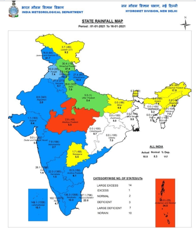
Between January 1 and January 16 this year, Tamil Nadu received the highest amount of rainfall of 136.3 mm followed by Kerala which received 102.1 mm. Meanwhile, Karnataka, Andhra Pradesh and Telangana received 22mm, 15mm and 1.7mm of rain respectively.
The rainfall amount of Kerala has the highest PDN -- 2,073, followed by Karnataka (1,365), Tamil Nadu (1,008), and Andhra Pradesh 150.
Telangana is the lone state whose January rains have so far remained a large deficit with its normal January rains being 5.4mm and the PDN returning a negative 68.
Normal rains in January for Tamil Nadu, Andhra Pradesh, Telangana, Kerala, and Karnataka are 12.3 mm, 6.1 mm, 5.4 mm, 4.7 mm, and 1.5mm respectively.
While it is time for (NEM) North East Monsoon's withdrawal from the southern states, experts project that it may turn to become the second wettest January since 1921, if not the wettest in the case of Tamil Nadu.
K Srikanth, one of the pioneers in weather blogging, based out of Chennai, had earlier forecasted the very heavy rain episode before Pongal at least a month ahead on December 11, 2020 itself, in a video he uploaded in his Chennai Rains handle.
Read: Delhi air quality 'Very Poor', likely to deteriorate further
"It is not necessary that all La Niña years you should witness large excess rainfall. It is normal for NEM to withdraw late during La Niña years. It will never be an annual phenomenon. Highest rainfall ever recorded for Tamil Nadu in January is 141.2mm in 1921 which, in fact, was an El Nino year," Srikanth said.
As regards to the frequency, the rain tracker observed that extreme weather episodes - hotter summers or extreme rainfall events, or both are manifestations of warming up of oceans.
"With the Arabian Sea and Bay of Bengal being the warmest water bodies in the earth, the Indian subcontinent is likely to witness such events much frequently and it is unlikely that the frequency will be lower," he said.
Subscribing to the views of Srikanth, N. Puviarasan, Director, the Area Cyclone Warning Centre at the Regional Meteorological Centre in Chennai, said that the unusually high rains were directly linked to the global effect.
"The La Niña negative index peak was reached in December 2020 due to which easterlies were strong. Our systems originate near Indonesia. Here the Ocean's surface temperature was warm, and the warm waters brought moisture to South, Tamil Nadu," he added.
On the recurrence next year, Puviyarasan too said it is highly unlikely to witness yet another wettest January of the century like this year. This year's January rains witnessed by Tamil Nadu were the wettest by far for a century as the data suggests January 1921 witnessed 141.2mm of rain.
Read: Puducherry: Oppn parties claim Narayanasamy govt has lost majority
What are El Niño and La Niña?
El Niño and La Niña are opposite phases of a naturally occurring yet complex global climate cycle known as the El Niño Southern Oscillation (ENSO).
El Niño, Spanish for boy child, has a tendency to onset around Christmas. It is an abnormal warming of water in the Equatorial Pacific Ocean every three to seven years and can last up to 18 months.
La Niña, Spanish for little girl, the antonym of El Niño, points to the abnormal cooling of the ocean temperatures in the same Pacific region.
What is La Niña?
During La Niña, the surface winds across the entire tropical Pacific are stronger than usual. Most of the tropical Pacific Ocean is cooler than average. Rainfall usually increases over Indonesia, where waters remain warm, and decreases over the central tropical Pacific which is cool. Over Indonesia, there is more rising air motion and a lower surface pressure. Sinking air motion exists over the cooler waters of the central and eastern Pacific.
What is El Niño?
During El Niño, the surface winds across the entire tropical Pacific are weaker than usual. Surface temperatures in the central and eastern tropical Pacific Ocean are warmer than average. Rainfall is below average over Indonesia and above average over the central or eastern Pacific. Rising air motion, which is linked to storms and rainfall, increases over the central or eastern Pacific, and surface pressure there tends to be lower than average. An increase in sinking air motion over Indonesia also leads to higher surface pressure and dryness.
Read: Karnataka vs Maharashtra: Yediyurappa, Oppn leaders slam Uddhav