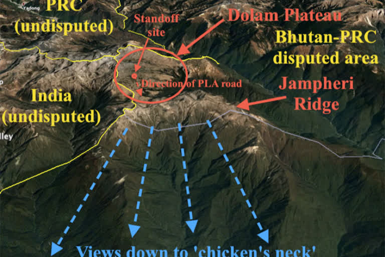
New Delhi: While the details of the ‘three-step roadmap’ agreement inked virtually between China’s Assistant Foreign Minister Wu Jianghao and Bhutan's Foreign Minister Lyonpo Tandi Dorji on October 15 remain shrouded in mystery, the fact that Chinese ‘dual-use’ ‘xiaokang’ (‘moderately prosperous’) villages are coming up southeast of the Doklam plateau may be indication that the Chinese ‘salami-slicing’ moves are aimed at gaining control of the Jampheri (Zompelri) Ridge.
The strategically-important Jampheri ridge is a geographical landmass that shoots up by about 500 metres from the craggy and desolate surroundings just north-northeast of the Chicken’s Neck or the Siliguri Corridor.
Usually identified as a Chinese tactic, ‘salami-slicing’ refers to the policy of slowly occupying disputed territory leading to a position where rival claimants have to ultimately accede to the new altered status quo in China’s favour.
Recently, satellite imagery tweeted on Tuesday by an acknowledged researcher with The Intel Lab said: “Disputed land between #Bhutan & #China near Doklam shows construction activity between 2020-21, multiple new villages spread through an area roughly 100 km² now dot the landscape, is this part of a new agreement or enforcement of #China's territorial claims?
Also read: Army steps up vigil along LAC in Arunachal Pradesh amid increased Chinese activities
This area is very close to the Doklam (Doka La) plateau, located near the India-Bhutan-China trijunction that was the flashpoint of a 73-day eyeball-to-eyeball faceoff between India and China in 2017.
The developments acquire significance in the backdrop of China having recently framed a sweeping and comprehensive border law to be effective from January 1, 2022.
What is interesting is that the Chinese villages believed to have been constructed between May 2020 and November 2021 are in Bhutanese territory, but align southwards more towards the Jampheri Ridge, which overlooks the Siliguri Corridor.
The about-60-km-long land corridor snaking between Bhutan in the north and Bangladesh in the south with 22 km at its narrowest point, the Siliguri corridor is a stretch through which all rail and road links pass through for connecting the Indian mainland with the Northeast region.
Therefore, during times of conflict, this stretch would be a very vulnerable target for attacks by enemy planes, while a Chinese control of the Jampheri Ridge would expose it to heavy artillery fire that would be able to target roads, bridges and also any moving object on the corridor.
While the Jampheri Ridge has a permanent force of the Royal Bhutanese Army deployed atop, it is not a serious factor that China’s ‘might is right’ diplomacy with Bhutan cannot overcome—which brings the core question of the details that the ‘three-step roadmap’ pact may contain.
Also read: India, China meet on border issues today
Interestingly, during the Doklam crisis of 2017, Chinese Foreign Ministry Spokesperson Lu Kang had presented a sketch map of Beijing’s interpretation of the territorial claims that followed the crest of the Jampheri Ridge.
Greater control in the Doklam plateau and the Jampheri Ridge would also test India’s capability to protect Bhutan thereby weakening India-Bhutan political ties and also put Bhutan under pressure to toe China’s line.


