ETV Bharat / bharat

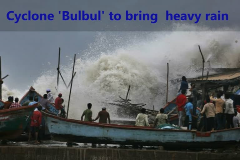
Cyclone 'Bulbul' to bring heavy rain; WB, Odisha prepare to face calamity

author img

By

Published : Nov 7, 2019, 11:56 PM IST

According to the Met department, cyclone 'Bulbul' over the Bay of Bengal is set to intensify into a very severe cyclonic storm, triggering heavy rain in parts of Odisha and West Bengal. The two states are bracing for the situation. It advised people in affected areas to remain indoors and total suspension of fishing from November 8.

Cyclone 'Bulbul' to bring heavy rain; WB, Odisha prepare to face calamity

Kolkata/Bhubaneswar: With the cyclone 'Bulbul' over the Bay of Bengal set to intensify into a very severe cyclonic storm, triggering heavy rain in parts of Odisha and West Bengal, the two states are bracing for the situation.

The Met department said that the cyclone, situated 750 kilometres south of Kolkata in the afternoon, is likely to intensify into a severe cyclonic storm by Thursday night and into a very severe cyclonic storm by Friday.

The governments of the two states are taking measures to ensure that damage from the storm is contained, even as the Centre assured them of all assistance.

The weatherman said the system is likely to move initially north-northwestwards and then nearly northwards till November 9.

It will then re-curve northeastwards towards Bangladesh and adjoining West Bengal, skirting Odisha, and cause heavy to very heavy rain in the coastal districts of North Odisha and West Bengal for three days from Friday.

Read: Watch: DK Shivakumar receives grand welcome by party workers in Mysuru

Taking note of the severity of the storm and possibility of damage to property and lives, the Centre has asked the West Bengal and Odisha government to take all steps to deal with 'Bulbul' and ensure there is minimum casualty and damage.

The weatherman predicted possible damage to thatched roofs, embankments and roads in the coastal districts of North Odisha and West Bengal.

It advised people in affected areas to remain indoors and total suspension of fishing from November 8.

At a high-level meeting in New Delhi, Principal Secretary to the Prime Minister, PK Mishra also assured the states of all necessary central assistance.

The meeting was convened in the wake of concern expressed by Prime Minister Narendra Modi.

Top officials of Odisha, West Bengal and Union Territory of Andaman and Nicobar Islands attended the meeting through video conference.

The Met said sea condition will be rough to very rough along and off Odisha and West Bengal coasts from Friday onwards and will become very high on Saturday and Sunday.

In West Bengal, fishermen have been advised to return to the coast by Thursday evening and not venture into the seas till the caution is lifted.

District officials have been asked to keep a tab on the situation and prepare for any contingency, a government functionary said.

The weatherman has forecast sustained wind speed of 120 to 130 km per hour with gusts of up to 140 kmph when the cyclone will be at its 'very severe' form on Friday and then lessen to a 'severe' cyclonic storm on November 9.

Under its impact, heavy to very heavy rainfall with extremely heavy rain at one or two places is likely to occur in the coastal districts of North and South 24 Parganas on November 9 and 10, the Met said.

It will also bring heavy rain in Kolkata East and West Midnapore, Howrah, Hooghly and Nadia district during the two days.

In Bhubaneswar, Special Relief Commissioner (SRC), PK Jena said as per IMD predictions, coastal Odisha is likely to experience wind speed of 70-80 kmph gusting up to 90 kmph on Friday accompanied by heavy to very heavy downpour.

In view of the weather condition, all schools and Anganwadi centres will remain closed on Friday and Saturday in Puri, Jagatsinghpur and Kendrapara districts, an official said in the Odisha capital.

However, the Met department's forecast that the cyclone may skip Odisha has come as a major relief to the people of the state, who are still struggling to return to normalcy post cyclone Fani in May that had claimed more than 64 lives and destroyed around five lakh houses.

Also, read: Naidu slams YSRC govt for spending over Rs 15 Cr on CM's House

ZCZC
PRI GEN NAT
.KOLKATA CAL19
LDALL CYCLONE
Cyclone 'Bulbul' to bring heavy rain; WB, Odisha prepare to
face calamity
         (Eds: incorporating related stories)
         Kolkata/Bhubaneswar, Nov 7 (PTI) With the cyclone
'Bulbul' over the Bay of Bengal set to intensify into a very
severe cyclonic storm, triggering heavy rain in parts of
Odisha and West Bengal, the two states are bracing for the
situation.
         The Met department said that the cyclone, situated 750
kilometres south of Kolkata in the afternoon, is likely to
intensify into a severe cyclonic storm by Thursday night and
into a very severe cyclonic storm by Friday.
         The governments of the two states are taking measures
to ensure that damage from the storm is contained, even as the
Centre assured them of all assistance.
         The weatherman said the system is likely to move
initially north-northwestwards and then nearly northwards till
November 9.
         It will then re-curve northeastwards towards
Bangladesh and adjoining West Bengal, skirting Odisha, and
cause heavy to very heavy rain in the coastal districts of
North Odisha and West Bengal for three days from Friday.
         Taking note of the severity of the storm and
possibility of damage to property and lives, the Centre has
asked the West Bengal and Odisha government to take all steps
to deal with 'Bulbul' and ensure there is minimum casualty and
damage.
         The weatherman predicted possible damage to thatched
roofs, embankments and roads in the coastal districts of North
Odisha and West Bengal.
         It advised people in affected areas to remain indoors
and total suspension of fishing from November 8.
         At a high-level meeting in New Delhi, Principal
Secretary to the Prime Minister, P K Mishra also assured the
states of all necessary central assistance.
         The meeting was convened in the wake of concern
expressed by Prime Minister Narendra Modi.
         Top officials of Odisha, West Bengal and Union
Territory of Andaman and Nicobar Islands attended the meeting
through video conference.
         The Met said sea condition will be rough to very rough
along and off Odisha and West Bengal coasts from Friday
onwards and will become very high on Saturday and Sunday.
         In West Bengal, fishermen have been advised to return
to the coast by Thursday evening and not venture into the seas
till the caution is lifted.
         District officials have been asked to keep a tab on
the situation and prepare for any contingency, a government
functionary said.
         The weatherman has forecast sustained windspeed of 120
to 130 km per hour with gusts of up to 140 kmph when the
cyclone will be at its 'very severe' form on Friday and then
lessen to a 'severe' cyclonic storm on November 9.
         Under its impact, heavy to very heavy rainfall with
extremely heavy rain at one or two places is likely to occur
in the coastal districts of North and South 24 Parganas on
November 9 and 10, the Met said.
         It will also bring heavy rain in Kolkata East and West
Midnapore, Howrah, Hooghly and Nadia district during the two
days.
         In Bhubaneswar, Special Relief Commissioner (SRC), PK
Jena said as per IMD predictions, coastal Odisha is likely to
experience wind speed of 70-80 kmph gusting up to 90 kmph on
Friday accompanied by heavy to very heavy downpour.
         In view of the weather condition, all schools and
anganwadi centres will remain closed on Friday and Saturday in
Puri, Jagatsinghpur and Kendrapara districts, an official said
in the Odisha capital.
         However, the Met department's forecast that the
cyclone may skip Odisha has come as a major relief to the
people of the state, who are still struggling to return to
normalcy post cyclone Fani in May that had claimed more than
64 lives and destroyed around five lakh houses.         PTI AMR SKN
ACB SNS AMR
NN
NN
11072243
NNNN
ETV Bharat Logo

Copyright © 2024 Ushodaya Enterprises Pvt. Ltd., All Rights Reserved.