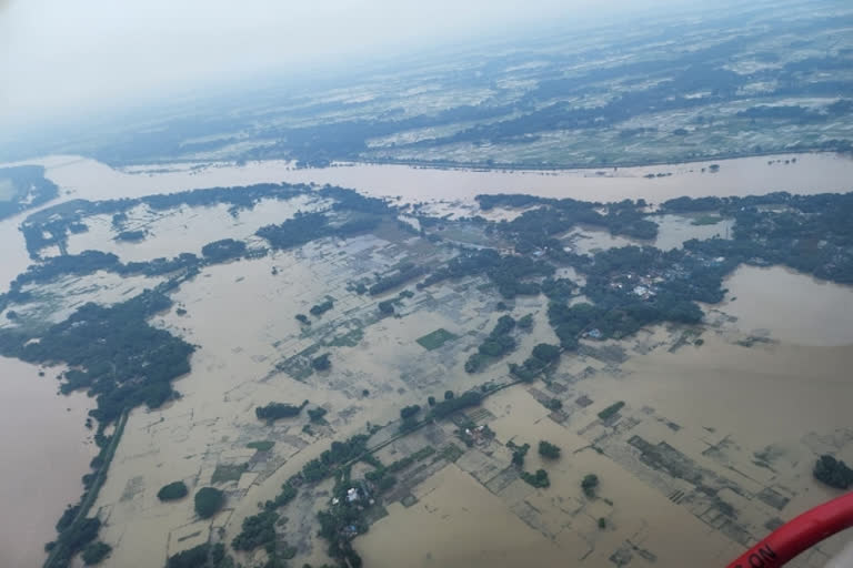
Bhubaneswar: This August recorded the highest rain in India. Several parts of the country, especially the eastern, central, and some western parts including Rajasthan, recorded excess rain during the first two weeks of August. Low-pressure areas have already formed in August, bringing extensive and heavy rain to east, central, and west India. Low-pressure areas are the main rain-bearing systems during the monsoon.
There is a well-marked low-pressure area over Odisha and Andhra Pradesh. Odisha has faced heavy floods due to low pressure. Kendrapara, Jagatsinghpur, Khurda, Puri, and Cuttack districts are the worst hit by the calamity. The meteorological department said a low-pressure system has been formed over northeast and adjoining areas of the east-central Bay of Bengal.
Odisha Chief Minister Naveen Patnaik on Thursday conducted an aerial survey of flood-affected areas of the Mahanadi river basin as around five lakh people in 12 districts are reeling under the deluge.
He visited the flood-affected areas of Khurda, Puri, Cuttack, Jagatsinghpur, and Kendrapada districts. CM Naveen Patnaik announced that relief will be provided for 15 days in flood-affected areas and damage will be estimated within 7 days of water release. Within 15 days, assistance will be provided to the affected people and relief will be provided for crop loss and house destruction.
As the meteorological department has predicted heavy rainfall in north Odisha, the government asked district collectors of Mayurbhanj, Keonjhar, Balasore, Bhadrak, and Jajpur to remain on alert.
Also read: More than 2 lakh people affected in Odisha flood
After a respite for a brief period, the Godavari river is again witnessing heavy floods in Telangana and Andhra Pradesh due to heavy rains upstream, posing threat to the low-lying areas and villages adjacent to the river bank. At the temple town of Bhadrachalam in Telangana’s Bhadradri Kothagudem district, the water level crossed the third danger mark of 53 ft and reached 54.5 ft by Wednesday.
At Dowleshwaram near Rajahmundry in Andhra Pradesh’s East Godavari district, the irrigation department authorities sounded a second warning signal, as they let out 1.435 million cusecs from the barrage into the river.
“We have pressed into service three teams of State Disaster Response Force (SDRF) and four teams of NDRF to take up rescue operations in the island villages of Ainavilli and Mamidikuduru in Konaseema district and Kunavaram in Alluri Sitarama Raju district, which are likely to face inundation and shift the people to safer areas,” AP State Disaster Management Authority managing director B R Ambedkar said in a statement.
Meanwhile, the Krishna river, too, continued to be in spate due to heavy rains in the upstream areas. Srisailam and Nagarjunasagar dams are filled to almost full reservoir levels, forcing the authorities to release over 377,000 cusecs of water downstream. At Prakasam barrage in Vijayawada, too, the authorities lifted all the gates to let out 315,000 cusecs of water.
The western part of the country also received rain. Rain lashed different parts of the state with Mount Abu tehsil recording the highest rainfall of 170 mm in a 24-hour period, officials said on Thursday. The Meteorological Department has forecast that rain activities will now stop for a few days in the state. According to the department, in the 24 hours till 8.30 am on Thursday, heavy to very heavy rain has been recorded at isolated places in Sirohi, Pratapgarh, Udaipur, Barmer, Jalore, and Jaisalmer districts of the state.
According to the Meteorological Department forecast, from today, there will be a sharp decrease in rain activities in most parts of western Rajasthan except Jaisalmer and Barmer. The weather will remain dry in most parts and rain is likely to occur only in isolated places. Another new low-pressure area is likely to form in the Bay of Bengal on August 19. Under its effect, a fresh round of rain will start in some parts of east Rajasthan from August 21.
Also read: Odisha gears up preparations to deal with 'medium flood' in Mahanadi basin
The Narmada river flows in spate causing a flood-like situation in the low-lying areas, officials said on Wednesday. The administration in Madhya Pradesh's Narmadapuram is on high alert. The water level of the river increased following torrential rains in the region over the last couple of days. The district officials added that the Narmada River in the area has touched the danger mark.
"The administration is on alert after water levels rose in Narmadapuram and touched the danger mark. While water levels have risen, we are still 1.5 feet away from alarming levels," NK Singh, the District Magistrate said. "We are prepared to handle the situation in case the water rises further and a flood situation erupts. We have already placed people across the river banks," he added.
"The opening of the gates of several dams have made the level of River Narmada reach the warning mark and we are making every possible effort to remove the water by regulating to control it," the CM said. The India Meteorological Department has predicted fairly widespread rainfall over the areas of Madhya Pradesh from Thursday to Sunday.
IMD’s Ranchi Meteorological Centre issued a forecast of light rain in isolated places over Jharkhand today. Weathermen said the monsoon trough was passing through Daltonganj, the headquarters of Palamu. The local forecast for Ranchi suggested one or two spells of rain today. An alert of thunder and lightning was also issued for isolated places. According to weathermen, most places would witness restricted rainfall activity on Thursday.
Meanwhile, heavy rain in several places across the country has prompted the respective district administrations to issue safety alerts.


