New Delhi: Users across India can now access hyperlocal air quality information on Google Maps, the tech titan said on Wednesday announcing Air View+, an AI-powered and ecosystem-based solution.
Google said Air View+ enables valuable air quality insights to government agencies responsible for environmental monitoring and urban planning, by offering citizens hyperlocal air quality information on Google Maps.
The company's latest move assumes significance as Delhi's air quality index (AQI) touched a high of 491 earlier this week, as toxic haze engulfed the national capital prompting the government to restrict vehicle movement and construction activities, and schools to shift to online classes.
Google, in a blog post penned by Yael Maguire, VP and GM, Google Maps Platform and Google Earth, along with Miriam Daniel, VP and GM, Google Maps, announced Air View+ which it said is an ecosystem-based solution to empower government authorities and people with hyperlocal air quality information.
As India continues its "incredible growth momentum", backed by tech innovation and demographic advantage, it is crucial to also mitigate risks that could slow it down, Google said in the blog post, adding that environmental issues are one such stumbling block, with air pollution topping the list.
"Air pollution not only diminishes the livability of our cities but it massively contributes to an overloaded healthcare system," it said.
While this aspect is widely understood and appreciated, the ability to take targeted action has been limited due to imperfect data around air quality at the hyperlocal level, Google said.
"To combat this challenge, today, we are pleased to announce Air View+ -- an ecosystem-based solution to empower government authorities and people with useful hyperlocal air quality information, in collaboration with local climate tech firms," it said.
Powered by Google AI, modelling a wide range of data inputs, Air View+ enables valuable air quality insights to government agencies responsible for environmental monitoring and urban planning. It would also enable real-time hyperlocal air quality information in Google Maps for users across India.
"People in India can now access hyperlocal air quality information across the country in Google Maps," it said.
Air View+ adopts an ecosystem-based approach, bringing together local organisations working to enable real-time hyperlocal air quality information, including local sustainability startups, researchers/climate action groups, corporations, city administrators, and citizens.
"Climate tech firms, Aurassure and Respirer Living Sciences were instrumental in setting up an air quality sensor network in cities that previously lacked the requisite infrastructure to monitor air quality," it explained.
These sensors measure various air quality parameters, PM2.5, PM10, CO2, NO2, Ozone, and VOCs, along with temperature and humidity, taking measurements every minute. Strategically deployed in static locations across more than 150 Indian cities, including administrative establishments, commercial buildings, and utility poles, to maximise population coverage, these sensors continuously monitor air quality.
With the support of local researchers from IIT Delhi, IIT Hyderabad, state pollution boards and climate action groups like CSTEP, these sensors are rigorously validated and calibrated.
This data is analysed using Google AI by researchers and sustainability startups to compute insights quickly and at scale, making this information useful for both citizens and city planners.
The solution empowers local municipal corporations with hyperlocal air quality data of their cities, which they are using to develop their in-house AQ dashboards via the researchers and sustainability partners (Aurassure and Respirer Living Sciences). These dashboards provide air quality data for unmonitored areas and help urban planners identify hotspots and make necessary interventions.
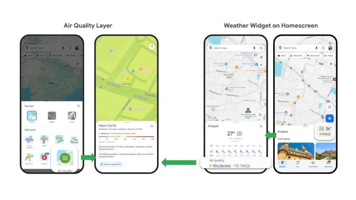
People can readily access AQI in Google Maps by selecting the Air Quality layer from the Layer button on the home screen and tapping on any location on the map or by clicking the Weather widget on the Explore tab on the home screen, for AQI info at their current location.
"This information is especially important for vulnerable populations such as young children or the elderly, enabling families to take appropriately preventative measures and precautions for their health such as using N95 masks or reducing outdoor exposure," the blog said.


