ETV Bharat / state

5.3 Magnitude Earthquake Hits Mulugu In Telangana, Tremors Felt In Hyderabad

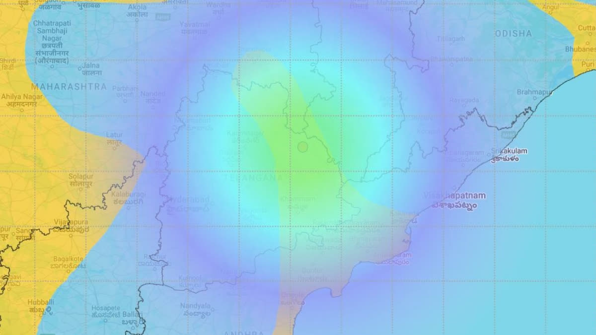
An earthquake of 5.3 magnitude on the Richter scale hit Mulugu in Telangana on Wednesday at 7:27 am, the National Center for Seismology said.

An earthquake of 5.3 magnitude on the Richter scale hit Mulugu in Telangana on Wednesday morning sparking fear and frenzy as the region rarely experiences such tremors.
Screengrab - Interactive map on the earthquake in Mulugu, Telangana. (National Center for Seismology)
author img

By ETV Bharat English Team

Published : Dec 4, 2024, 8:07 AM IST

Updated : Dec 4, 2024, 9:37 AM IST

Mulugu: An earthquake of 5.3 magnitude on the Richter scale hit Mulugu in Telangana on Wednesday morning sparking fear and frenzy as the region rarely experiences such tremors.

The National Center for Seismology said the quake struck at 7.27 am and its depth was 40 km. Tremors were felt at several places in Telangana and nearby Andhra Pradesh. Mulugu is situated around 219 kilometres from Hyderabad.

Residents there experienced the tremors early in the morning. As of now, no damage or casualties have been reported. However, authorities are closely monitoring the situation.

The Indian Seismology Centre identified the location in the forests of Eturngaram. However, the US Geological Survey monitoring station said that the earthquake originated on the banks of the Godavari River.

Tremors were felt in Kothagudem, Manuguru, Bhadrachalam, Charla, Chintakani, and Nagulavancha areas. Vijayawada and Jaggayyapet town in Andhra Pradesh also experienced the tremors which lasted for a few seconds.

According to Balaji Tarini aka 'Telangana Weatherman', this is the first time in 20 years that such a strong earthquake occurred in Telangana. The last time such a strong earthquake shook the region was on September 30, 1993 with a magnitude of 6.2.

Telangana falls under Seismic Zone II (low-intensity zone)

In a written reply in Parliament in 2021, the government said considering the recorded history of earthquakes in the country, a total of 59% of the land mass of India (covering all states of India) is prone to earthquakes of different intensities.

As per the seismic zoning map of the country, the total area is classified into four seismic zones. Zone V is seismically the most active region, while zone II is the least. Approximately, 11% area of the country falls in zone V, 18% in zone IV, 30% in zone III and the remaining in zone II.

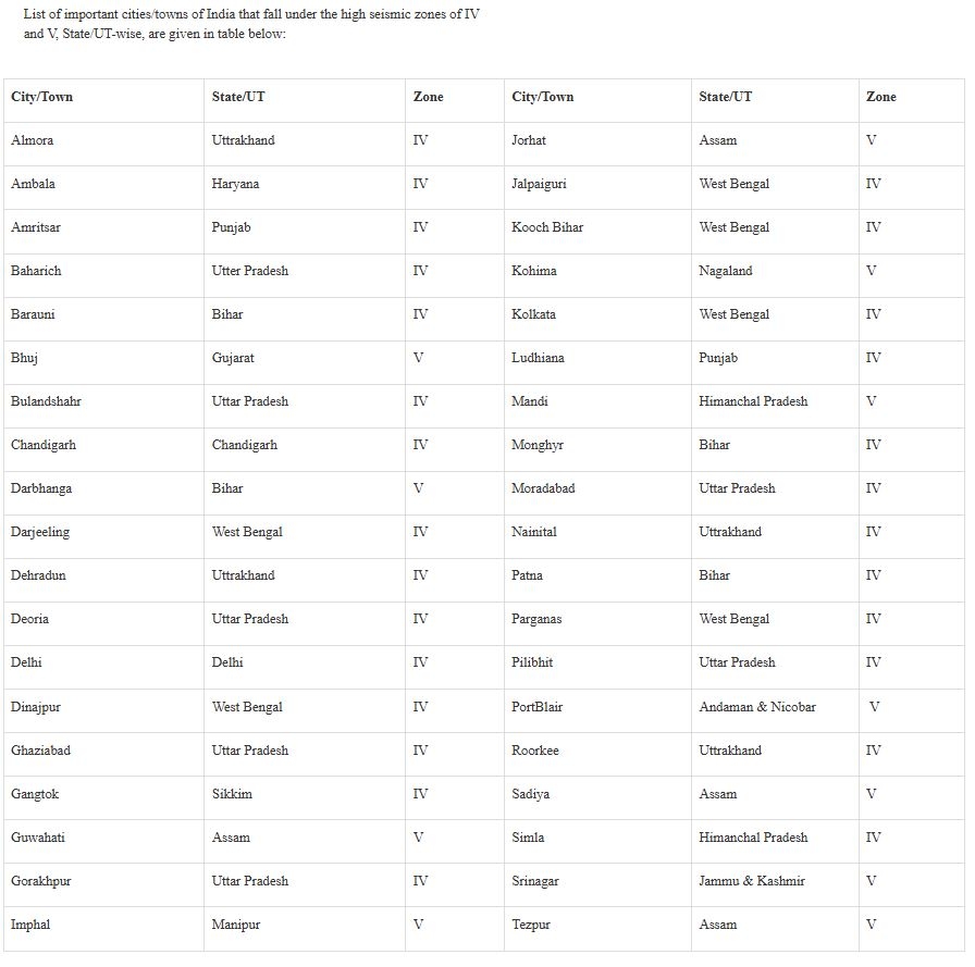
List of areas in India falling in Zone IV and V

Here is a list of important cities and towns in India that fall under the high seismic zones of IV and V.
An earthquake of 5.3 magnitude on the Richter scale hit Mulugu in Telangana on Wednesday morning sparking fear and frenzy as the region rarely experiences such tremors.
List of areas in India falling in Zone IV and V (Ministry of Earth Sciences)

The National Centre for Seismology under the Ministry of Earth Sciences is the nodal agency of the Government of India, for monitoring earthquakes in and around the country. For this purpose, NCS maintains a National Seismological Network (NSN) consisting of 115 observatories spread across the country. The information on earthquakes reported by NCS is disseminated to the concerned central and state disaster authorities in the least possible time to initiate adequate mitigation measures.

Read More
  1. 3.6 Earthquake Jolts Several Jharkhand Districts, Some Houses Develop Cracks
  2. Gujarat: 3.7 Magnitude Earthquake Hits Savar Kundla Area of Amreli District

Mulugu: An earthquake of 5.3 magnitude on the Richter scale hit Mulugu in Telangana on Wednesday morning sparking fear and frenzy as the region rarely experiences such tremors.

The National Center for Seismology said the quake struck at 7.27 am and its depth was 40 km. Tremors were felt at several places in Telangana and nearby Andhra Pradesh. Mulugu is situated around 219 kilometres from Hyderabad.

Residents there experienced the tremors early in the morning. As of now, no damage or casualties have been reported. However, authorities are closely monitoring the situation.

The Indian Seismology Centre identified the location in the forests of Eturngaram. However, the US Geological Survey monitoring station said that the earthquake originated on the banks of the Godavari River.

Tremors were felt in Kothagudem, Manuguru, Bhadrachalam, Charla, Chintakani, and Nagulavancha areas. Vijayawada and Jaggayyapet town in Andhra Pradesh also experienced the tremors which lasted for a few seconds.

According to Balaji Tarini aka 'Telangana Weatherman', this is the first time in 20 years that such a strong earthquake occurred in Telangana. The last time such a strong earthquake shook the region was on September 30, 1993 with a magnitude of 6.2.

Telangana falls under Seismic Zone II (low-intensity zone)

In a written reply in Parliament in 2021, the government said considering the recorded history of earthquakes in the country, a total of 59% of the land mass of India (covering all states of India) is prone to earthquakes of different intensities.

As per the seismic zoning map of the country, the total area is classified into four seismic zones. Zone V is seismically the most active region, while zone II is the least. Approximately, 11% area of the country falls in zone V, 18% in zone IV, 30% in zone III and the remaining in zone II.

List of areas in India falling in Zone IV and V

Here is a list of important cities and towns in India that fall under the high seismic zones of IV and V.

An earthquake of 5.3 magnitude on the Richter scale hit Mulugu in Telangana on Wednesday morning sparking fear and frenzy as the region rarely experiences such tremors.
List of areas in India falling in Zone IV and V (Ministry of Earth Sciences)

The National Centre for Seismology under the Ministry of Earth Sciences is the nodal agency of the Government of India, for monitoring earthquakes in and around the country. For this purpose, NCS maintains a National Seismological Network (NSN) consisting of 115 observatories spread across the country. The information on earthquakes reported by NCS is disseminated to the concerned central and state disaster authorities in the least possible time to initiate adequate mitigation measures.

Read More

  1. 3.6 Earthquake Jolts Several Jharkhand Districts, Some Houses Develop Cracks
  2. Gujarat: 3.7 Magnitude Earthquake Hits Savar Kundla Area of Amreli District
Last Updated : Dec 4, 2024, 9:37 AM IST
ETV Bharat Logo

Copyright © 2025 Ushodaya Enterprises Pvt. Ltd., All Rights Reserved.