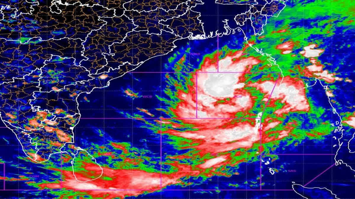
Bhubaneswar: Cyclone Dana is set to make landfall between Bhitarkanika in Kendrapada and Dhamra in Bhadrak district between October 24 midnight and the early hours of October 25, the India Meteorological Department (IMD) confirmed. The storm, currently located 520 km southeast of Paradip in the east-central Bay of Bengal, is advancing in a north-northwest direction at a speed of 15 km per hour. Having intensified into a cyclone earlier on Wednesday, Dana is expected to develop into a severe cyclonic storm by Thursday morning as it approaches the coastline, said Mrutyunjay Mohapatra, DG, IMD.
From Wednesday evening, the weather will start changing, showing signs of approaching cyclone, said Das adding, red alert has been issued for October 24 and 25, in places like Jagatsinghpur, Balasore, Kendrapara, Bhadrak and Mayurbhanj districts where heavy to very rainfall upto 20 cms is likely. The nearby districts will also come under yellow alert and witness heavy rainfall. Bhubaneswar is expected to see wind speeds of 60-70 km/h and heavy rain in the coming days.
A Cyclonic Storm “DANA” over eastcentral Bay of Bengal is very likely to move northwestwards and intensify into a severe cyclonic storm over northwest Bay of Bengal by early morning of 24th October.#IMDWeatherUpdate #imd #bayofbengal #weather #weatherforecast #weatherupdate… pic.twitter.com/Oq2hBC62Aa
— India Meteorological Department (@Indiametdept) October 23, 2024
"The windspeed will be highest 100 to 120 km/h in all the coastal districts on October 24 while light to moderate rainfall will start from Wednesday evening in most coastal areas. With time, the severe cyclonic storm will bring along extremely heavy rainfall upwards of 20 cms. This is applicable to both Odisha and West Bengal coastal areas where due to heavy rains, tidal waves of about one to two meters will also inundate large areas on October 25. The storm surge will definitely cause flooding and water logging. It is likely lead to massive damage and destruction to standing crops, thatched and tin houses, electric and telephone poles besides disrupting traffic," Mohapatra warned.
Subject: Cyclonic storm “DANA” over eastcentral Bay of Bengal (Cyclone Warning for Odisha and West Bengal coasts: Orange Message)
— India Meteorological Department (@Indiametdept) October 23, 2024
The cyclonic storm “DANA” (pronounced as Dana) over Eastcentral Bay of Bengal moved northwestwards with a speed of 13 kmph during past 6 hours and… pic.twitter.com/m6XrycmjN7
The IMD has issued danger code 10 for Puri, Dhamra, and Paradip, while Gopalpur has been placed under danger code 8. Current forecasts suggest wind speeds of 85 km/h near the storm’s center, with the cyclone’s outer clouds already starting to affect parts of the coastline as per the Paradip Port radar, said Uma Shankar Das, scientist IMD.
Kendrapada and Bhadrak Brace for Impact
Kendrapada and Bhadrak districts are expected to bear the brunt of the storm. Preparations for the cyclone are nearing completion in these areas. Should Dana maintain its current trajectory, the coastal regions and the interior saline forests are likely to be the most severely impacted. During landfall, wind speeds are projected to reach 100-110 km per hour, with gusts up to 120 km per hour.
Bhitarkanika Mangrove Forests Saving Grace
As Cyclone Dana approaches Odisha, authorities are banking on the Bhitarkanika mangrove forest to shield coastal regions from the storm’s impact. The mangrove forest, spanning nearly 200 sq km, is expected to play a crucial role in reducing tidal surges and mitigating wind speed in the areas surrounding the landfall zone. Principal Chief Conservator of Forests (Wildlife) Susanta Nanda emphasized that the presence of mangroves would help limit damage to the coast by acting as a natural barrier. “The mangrove forest will absorb much of the cyclone’s energy, lowering wind speeds and preventing severe tidal surges from impacting coastal lands,” Nanda said.
To ensure safety, the forest department has mobilized five teams to clear uprooted trees blocking roads and two special teams to manage potential crocodile incursions into human habitations. Bhitarkanika National Park, home to many wild species, including deer and crocodiles, has set a Standard Operating Procedure (SOP) for cyclone response. Nanda explained that while most animals instinctively seek shelter during such events, crocodiles may move into nearby villages during high tidal surges.“We have prepared our teams to rescue these animals if necessary,” he added.
Cyclone Readiness Across the State
The Divisional Forest Officer (DFO) of Rajnagar, Sudharshan G Yadav, confirmed that forest officials are on high alert with all necessary rescue equipment in place. A control room has been set up, operating 24/7, and patrol boats have been moved to safe locations to avoid damage.
Heavy Rainfall Expected Across 14 Districts
Along with high winds, the state is expected to experience heavy rainfall. IMD has issued red and yellow warnings for 14 districts, including coastal, northern, and interior regions of Odisha. Heavy to very heavy rainfall is expected to begin tomorrow and continue through the 25th. All fishing and shipping activities have been suspended, and fishermen have been warned against venturing into the sea until the storm passes.
Mass Evacuations Underway
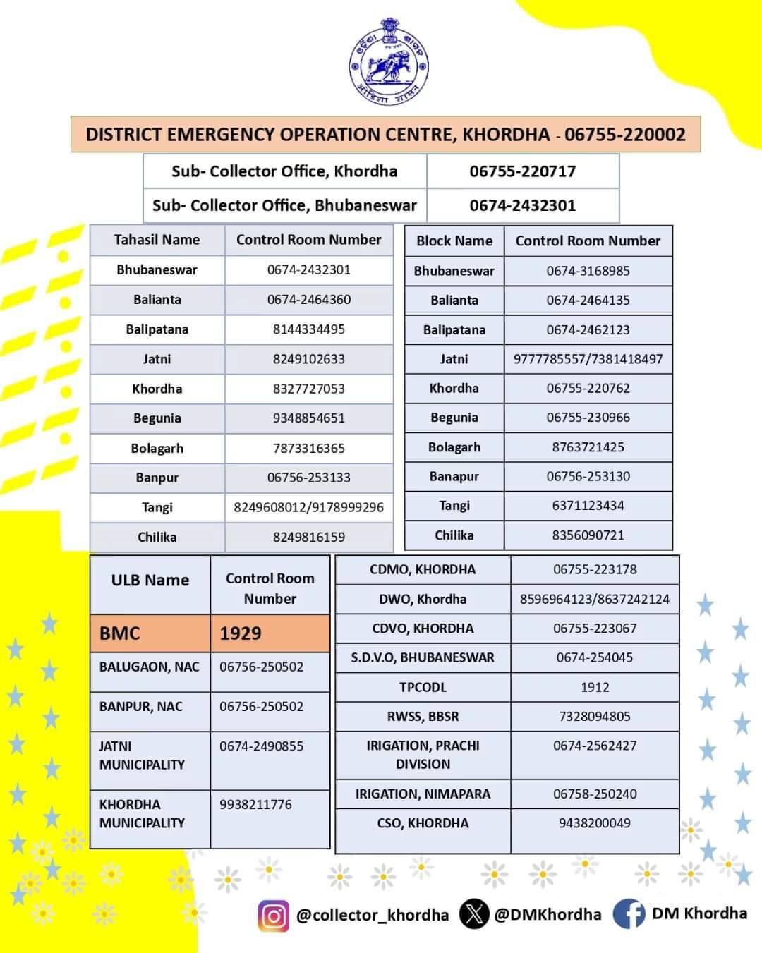
The state administration has begun the evacuation of nearly 10 lakh people from coastal districts, moving them to 6,244 relief and storm shelters. Six secretaries from the state government have been assigned to oversee cyclone management in the six districts most at risk. Senior ministers are coordinating the relief, rescue, and restoration operations. Chief Minister Mohan Majhi has called on all MLAs to remain in their constituencies to assist residents and work alongside local authorities to manage the cyclone response. District-wise emergency helpline and control room numbers have also been issued for all the vulnerable districts.
TOLL-FREE NUMBER FOR CYCLONE DANA, (TOLL FREE-1077)
1. BALESORE- CONTROLL ROOM-06782-262286, 06782-261077
2. MAYURBHANJA- CONTROLL ROOM-06792-252759, 06792-252941
3. BHADRAK-CONTROLL ROOM-06784-251881
4. JAJPUR- CONTROLL ROOM-06728-222648
5. KENDRAPADA- CONTROLL ROOM-06727-232803
6. KEONJHAR- CONTROLL ROOM-06766-255437
7. JAGATSINGHPUR- CONTROLL ROOM-06724-220368
8. CUTTACK- CONTROLL ROOM-0671-2507842
9. DHENKANAL- CONTROLL ROOM-06762-226507,06762-221376
10. ANGUL- CONTROLL ROOM-06764-230980
11. PURI- CONTROLL ROOM-06752-223237
12. KHURDA- CONTROLL ROOM-06755-220002
13. GANJAM- CONTROLL ROOM-06811-263978
14. NAYAGADA- CONTROLL ROOM-06753-252978
15. BMC (BBSR) TOLL FREE NUMBER-1929

Meanwhile, the Odisha Public Service Commission has postponed the OCS preliminary examination 2023 scheduled for the 27th in view of the cyclone Dana.
Former CM Naveen Patnaik's Message
Meanwhile, Naveen Patnaik, Leader of the Opposition in the Odisha Assembly, urged citizens to remain calm but vigilant. “Odisha has faced numerous cyclones before, and our people have always shown resilience. Let us remain cautious and take necessary precautions to protect ourselves and our communities,” Patnaik said. Patnaik, who has consistently championed “zero casualty” policies following his experience in the 1999 super cyclone, reminded the public of the importance of cooperation with authorities. His appeal comes as mass evacuations are already underway across coastal districts, with over 10 lakh people being relocated to storm shelters.
ସମ୍ଭାବ୍ୟ ବାତ୍ୟା 'ଦାନା' ନେଇ ଭୟଭୀତ ହୁଅନ୍ତୁ ନାହିଁ। ସଜାଗ ରୁହନ୍ତୁ, ନିରାପଦ ରୁହନ୍ତୁ। ଜୀବନ ବଡ଼ ଅମୂଲ୍ୟ। ପୂର୍ବ ପରି ଆମେ ସମସ୍ତେ ଏକାଠି ଏଥର ମଧ୍ୟ ବାତ୍ୟାର ସଫଳ ମୁକାବିଲା କରିପାରିବା ବୋଲି ମୋର ଦୃଢ଼ ବିଶ୍ୱାସ। #EveryLifeIsPrecious #CycloneDana #Odisha pic.twitter.com/XKodMQ0ka2
— Naveen Patnaik (@Naveen_Odisha) October 23, 2024


