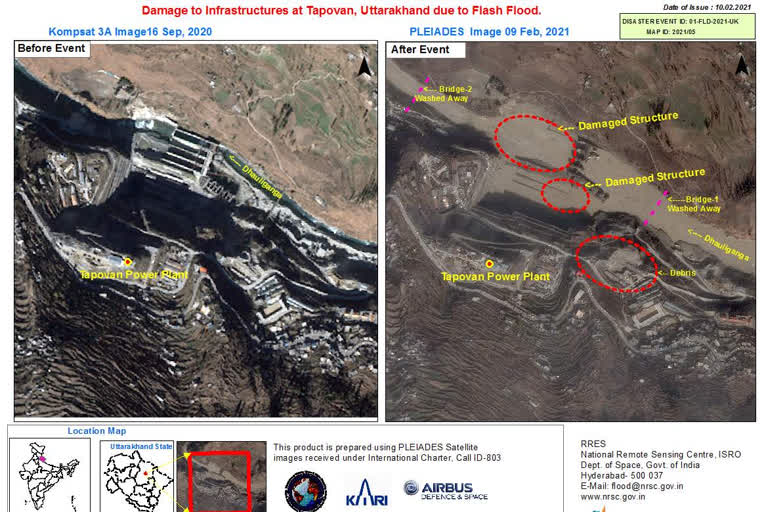
Bengaluru (Karnataka): The Indian Space Research Organisation (ISRO) on Wednesday released the first satellite images of the Uttarakhand disaster, showing infrastructure damage in Rishi Ganga and Dhauli Ganga river catchment areas.
Satellite images from after the incident show debris deposition in Dhauli Ganga, while other images displayed damage at dam infrastructures at Tapovan and Raini due to the flash floods.
Satellite images released by ISRO The images were captured by the space agency's advanced earth imaging and mapping satellite CARTOSAT-3, and analysis was done by ISRO's National Remote Sensing Centre in Hyderabad.
Satellite images released by ISRO The images were made public even as agencies continued rescue operations in Chamoli and adjoining areas of Uttarakhand. A DRDO team is working along with ISRO scientists and experts to ascertain the cause of the unfortunate incident.
Read:Chamoli disaster: Third day of rescue operation
As CARTOSAT-3 is a third-generation agile satellite with high-resolution imaging capabilities, these images might help in identifying the cause.
Satellite images released by ISRO Earlier this week, Uttarakhand Chief Minister Trivendra Singh Rawat said that as per the team of ISRO there was no glacier burst in Chamoli but rather it was the result of a sudden slide of snow accumulated on top of the mountain.
ISRO releases satellite images of Uttarakhand disaster When categorically asked if ISRO had indeed stated that it was not a glacier burst, the Chief Minister said, "The team of ISRO as per their report said that it was not a glacier burst. And it is also not an avalanche-prone area."
Read:WATCH: ETV Bharat's ground zero report from rescue site in Uttarakhand
