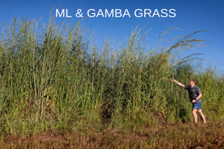
CSIRO, Australia: The perennial Gamba grass, originally from Africa, is listed as a Weed of National Significance and is one of five introduced grass species that pose extensive and significant threats to Australia’s biodiversity. This can grow up to as tall as 4 meters. In the dry season, it can pose threat and lead to hot fires. Moreover, Northern Australia is so vast that the on-the-ground mapping and even airborne detection of the weed becomes too labor-intensive.
So, the researchers at CSIRO turned to high-quality satellite imagery and developed a technique that could help detect and prioritize gamba grass for management. This was done by using field data to train a machine learning model.
Dr. Shaun Levick from Australia’s national science agency, CSIRO, said, " “Under optimum conditions, our method can detect gamba grass presence with about 90 percent accuracy.”
WorldView-3 satellite was used to capture very high-resolution imagery across 16 spectral bands for an area of 205 square kilometers near Batchelor in the Northern Territory – an area of dense gamba grass infestation.
“We knew that gamba grass tends to stay green longer into the dry season than native grasses, so we timed the capture of the satellite imagery for this period,” Dr. Rossiter-Rachor of Charles Darwin University said.
